

MAP 2026
1. General Overview
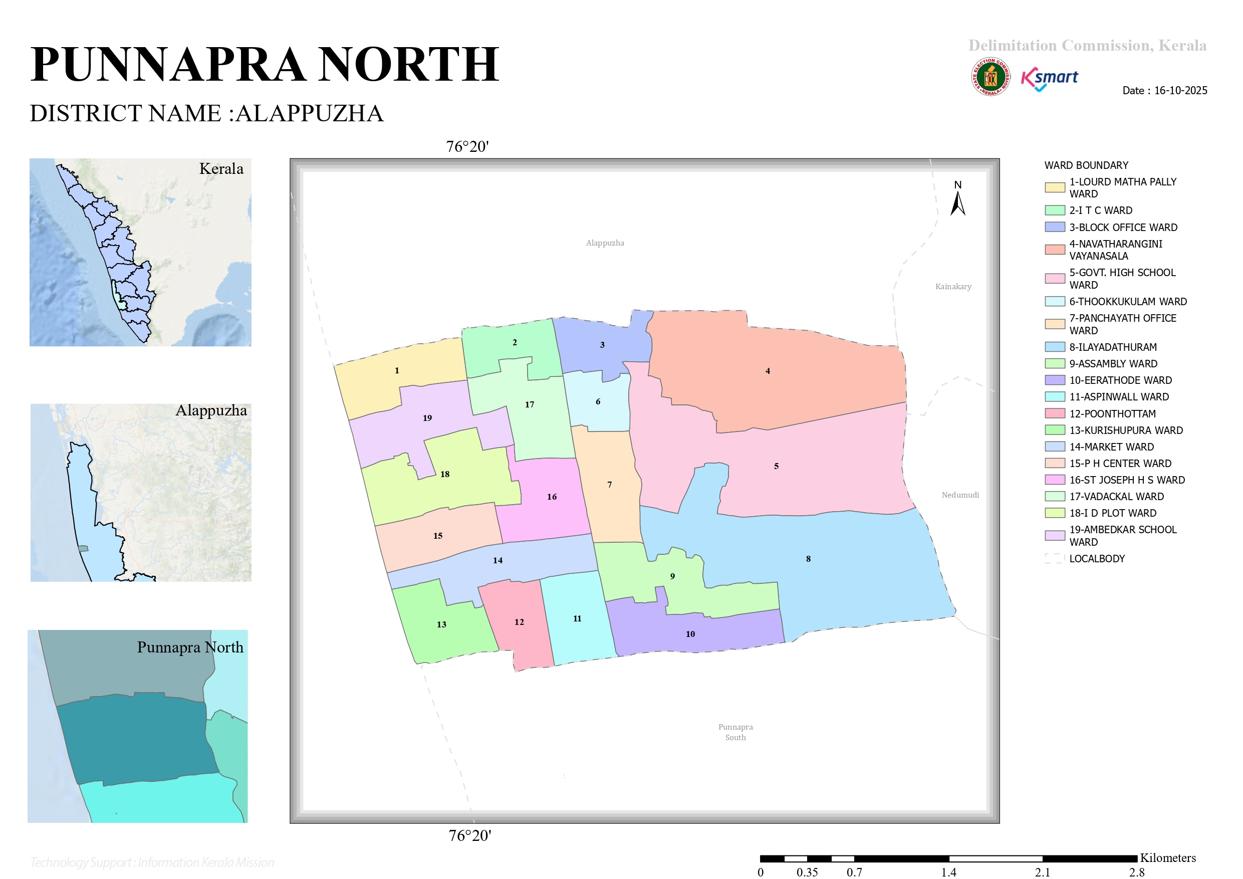
The presented map is the official ward delimitation map of Punnapra North Grama Panchayat in Alappuzha District. According to the map, the Panchayat consists of 19 wards. It is a coastal local self-government institution located to the south of Alappuzha town.
The map clearly depicts the Panchayat boundaries, ward divisions, neighboring local self-government institutions, a north arrow, and a scale bar.
2. Geographical Location
Punnapra North Grama Panchayat
- District: Alappuzha
- Taluk: Ambalappuzha
- Latitude–Longitude: Approximately 9°30′ N latitude and 76°20′ E longitude
- Physiography: Coastal plain region
Boundaries
| Direction | Boundary |
|---|---|
| North | Alappuzha Municipality |
| South | Punnapra South Grama Panchayat |
| East | Nedumudi Panchayat Area |
| West | Arabian Sea Coastal Region |
3. Ward Structure
The Panchayat comprises 19 wards.
List of Wards
| Ward No. | Ward Name |
|---|---|
| 1 | Lourdes Matha Pally Ward |
| 2 | ITC Ward |
| 3 | Block Office Ward |
| 4 | Navathanarangini Vayanasala Ward |
| 5 | Government High School Ward |
| 6 | Thookkukulam Ward |
| 7 | Panchayat Office Ward |
| 8 | Elayadathuram Ward |
| 9 | Assembly Ward |
| 10 | Erathode Ward |
| 11 | Aspinwall Ward |
| 12 | Poonthottam Ward |
| 13 | Kurishupura Ward |
| 14 | Market Ward |
| 15 | PH Centre Ward |
| 16 | St. Joseph H.S. Ward |
| 17 | Vadackal Ward |
| 18 | ID Plot Ward |
| 19 | Ambedkar School Ward |
4. Physiographic Analysis
(A) Central Region
- Wards 6, 7, 16, and 17 form the central part of the Panchayat.
- Panchayat Office Ward (Ward 7) functions as the administrative center.
- Block Office Ward (Ward 3) serves as an important administrative service hub.
(B) Eastern Region
- Wards 4, 5, 8, 9, and 10 are located in the eastern part.
- Ward 8 (Elayadathuram) appears to be the largest ward in terms of area.
- This region is likely characterized by water bodies and low-lying lands.
(C) Western Region
- Wards 1, 13, 15, 18, and 19 lie in the western sector.
- This area exhibits a stronger coastal character.
- Fishing, coir-based industries, and coconut cultivation are likely to be important economic activities.
(D) Southern Region
- Wards 10, 11, 12, and 13 are situated along the southern boundary.
- These wards maintain direct connectivity with Punnapra South Grama Panchayat.
5. Development Potential
Administrative Opportunities
- E-governance services can be expanded by utilizing the Panchayat Office and Block Office as administrative hubs.
- Public service centers may be decentralized and strengthened at the ward level.
Infrastructure Development
- Drainage systems in the eastern region require strengthening and modernization.
- Coastal protection and anti-sea erosion projects can be implemented in vulnerable wards.
- Road connectivity between wards can be improved through integrated transportation planning.
Social Development
- Social development clusters may be created around schools, health institutions, and libraries.
- Youth and women empowerment programmes can be implemented on a ward-wise basis.
6. SWOT Analysis
Strengths
- Proximity to Alappuzha town
- Good road connectivity
- Combination of coastal and peri-urban characteristics
- Presence of educational and administrative institutions
Weaknesses
- Waterlogging in low-lying areas
- Threat of coastal erosion and sea intrusion
- High population density in certain wards
Opportunities
- Tourism development
- Fisheries-related industries
- Digital governance initiatives
- Green and sustainable development projects
Threats
- Climate change impacts
- Coastal erosion
- Flooding and waterlogging risks
- Environmental pollution
7. Conclusion
Based on the map analysis, Punnapra North Grama Panchayat is a coastal local self-government institution with considerable administrative, social, and economic development potential. Comprising 19 wards, the Panchayat reflects both the urban influence of Alappuzha town and the distinctive characteristics of a coastal rural region.
The ward map serves as an important planning document for ward-level development planning, water resource management, coastal protection, infrastructure development, and sustainable local governance. Through strategic planning and community participation, the Panchayat has the potential to emerge as a model coastal local body in Kerala.